


‘An Illini Place’ showcases campus history
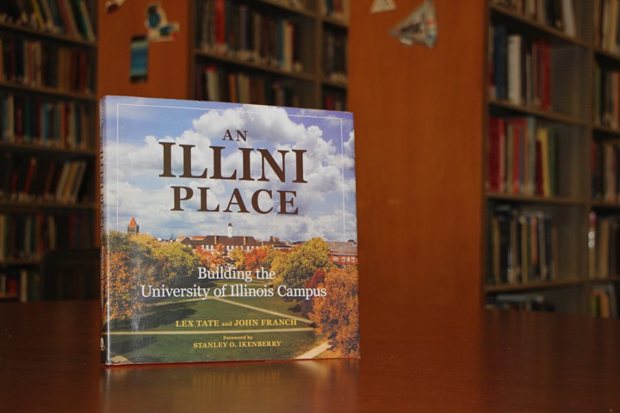
An Illini Place is a book by Lex Tate and John Franch, graduates of the College of Media. The book provides readers with the history of campus buildings, developmental plans and more.
October 17, 2017
Though most students walk past the red brick buildings of our campus every day, they don’t often stop to question their stories. The names of many people who helped build our campus are on plaques and signs across town, but we are not often familiar with the stories behind those names.
Lex Tate, adjunct lecturer in journalism and advertising at the University, and John Franch, researcher for the University Archives, recently co-authored “An Illini Place” to tell these stories.
Tate and Franch, along with Stanley Ikenberry, former University President, presented their new book on Friday at the Grainger Engineering Library IDEA Lab in conjunction with a presentation about the Mapping History at the University of Illinois project.
Tate, a 1972 graduate of the University, began as an English major before joining the two-year journalism program. After graduating, she worked at the News-Gazette and then the Champaign-Urbana Courier.
Tate later worked in public relations for Ikenberry. She continued to work in the office through the presidencies of Ikenberry’s next two successors, James Stukel and B. Joseph White. In 2003, she began lecturing in journalism and advertising.
Get The Daily Illini in your inbox!
While Tate was working in the Office for University Relations, Roland Kehe, a University architect, approached her with a book idea.
“Roland came to my office in the Henry Administration Building and he said, ‘I’m thinking about finding a way to get a book done about planning the University because there was one done in 1940.’ And he said, ‘Do you know anybody who might be interested?’” Tate said.
Tate told Kehe, “If you wait till I retire, I’d love to do it.”
Kehe and Tate then raised funds and wrote a proposal. Tate said they wanted the book to be less about the planning of the school and more about the school as a whole.
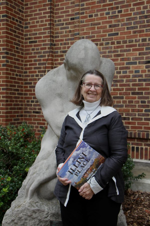
An Illini Place is a book by Lex Tate and John Franch, graduates of the College of Media. Pictured here, Tate is a lecturer in journalism and advertising at the University.
Tate then spent the next 10 years writing the book along with co-writer Franch, a former journalism student. Tate hired him to be the researcher for the book.
“I’d say, ‘Well, what about this?’ and ‘What about that?’ and ‘Who is this person?’” Tate said about her work with Franch.
For several years, Tate created folders for different aspects of campus — from the buildings, to the people, to the 86 different campus plans.
The book itself includes a chapter that takes a chronological look at campus development, and another called “The Neighborhood: Sleep, Eat, Pray” which describes developments in housing, food on campus and the rise of many churches.
Readers will learn about how black students were only allowed to eat at local restaurants in the north part of town, so at the time the University had a lunchroom in the English Building basement.
The book also tells the history of the churches on Wright Street and their foundations on campus, three of which were the first of their kind in the country.
Another chapter is called “Gifts and Givers,” and describes the buildings that were gifted to the University and whom they were gifted by.
For example, there is a love story behind Tina Weedon Smith Memorial Hall.
Tina Weedon Smith met her husband, Thomas Smith, a Union captain in the Civil War, in Tennessee. They married a few years later and moved to Champaign, where he was a lawyer and a member of the University of Illinois Board of Trustees.
“(Smith’s husband) knew how much she liked music, so he gave the University the money and a bunch of land … and for about a quarter of a million dollars, he … built the Smith Memorial Music Hall. Smith Hall is a memorial to Tina Weeden Smith. It’s a love story,” Tate said.
In the same chapter, readers learn the origin stories of the Beckman Institute for Advanced Science and Technology, the Krannert Center for the Performing Arts, the Krannert Art Museum, Foellinger Auditorium, the Thomas M. Siebel Center for Computer Science and more, including about 30 gifted buildings overall.
The final chapter describes the icons of the University, including the Main Quad and the Alma Mater sculpture.
The Mapping History Project, which was the other topic of the presentation Friday, was presented by Ellen Swain, archivist for student life and culture, James Whitacre, geographic information systems specialist, the University Archives and the University Library Scholarly Commons.
They discussed how Swain and Marci Uihlein, associate professor in architecture, wanted to do something for the University’s sesquicentennial that was related to the students.
Swain and Uihlein melded geographic information systems, architecture and the archives to create this project. They obtained funding from the University of Illinois Library Innovation Fund, the Stewart Howe Endowment fund, Student Life and Culture Archives and the Illinois School of Architecture.
They began the mapping project in January 2016, which features three main sections: campus history, interactive maps and map archives.
Franch, co-author of “An Illini Place” and historian for the mapping project, wrote brief histories, which were accompanied by photographs, home movies and oral histories. Archival videos and photo albums were also included.
Another crucial part of the project is that it features 3-D and hand-drawn maps.
Whitacre worked on the data that drives the maps. His primary focuses were the “campus historic maps and timeline,” which model the campus over time in 2-D space.
He said they took today’s buildings and deconstructed them to make the older maps. For buildings that didn’t exist, they looked at maps and aerial imagery.
History interns, James Scholar students and others also contributed to the project.
“(It’s) a place to showcase student work,” Swain said. “The idea is that this will never be finished.”