Facebook
Instagram
X
Tiktok
YouTube
The Daily Illini
Search this site
Submit Search
The Daily Illini
News
University
Around Campus
C-U
Around the World
Longform
Sports
Men’s Sports
Baseball
Men’s Basketball
Cross Country
Football
Golf
Men’s Gymnastics
Tennis
Men’s Track & Field
Wrestling
Women’s Sports
Women’s Basketball
Cross Country
Golf
Gymnastics
Soccer
Softball
Swim & Dive
Tennis
Women’s Track & Field
Volleyball
Columns
Club Sports
Hockey
Wheelchair Basketball
Podcasts
Features
Education & Campus Life
Around Town
Culture & Diversity
Business, Tech & Science
Arts & Entertainment
buzz
Best of CU
Community
Music
Columns
Featured Flicks
Music Reviews
Food Reviews
Book Reviews
Game Reviews
Festival Coverage
Pygmalion
Lollapalooza
Opinions
Columns
Politics
Culture
World
Health
Business & Tech
Campus Scout
Editorials
Perspectives
Letters to the Editor
Photo
Galleries
ILLordle
Salary Guide
CU Faith & Life
Housing
Time Machine
Hall of Fame
Special Sections
Moms Weekend
Dads Weekend
New Student Edition
International Student Guide
Humans of C-U
Housing Guide
Technograph
I on Illini
Black History Month
Graduation Guide
Wellness Edition
Sex and Dating Guide
LGBTQ Edition
Asian Heritage Edition
Sustainability Edition
Submit a Tip
More
Menu
The Daily Illini
🗞️ print
📣 news
Longform
🌺 life and culture
💬 opinions
🏅 sports
🎵 buzz
📸 photo
🔅 CU Faith & Life
🏡 housing
💸 salary guide
✨ special sections
💌 subscribe
Newsletter
Press Box
Instagram
Facebook
Twitter
Paper
❓ about
Advertise
Archives
Apply
Contact us
Corrections Policy
Ethics Code
Submit a Tip
Staff
Terms of Use
🎨 Illini Media Company
Donate
WPGU 107.1
Illio Yearbook
More
The Daily Illini
Open Search Bar
Search this site
Submit Search
Menu
News
University
Around Campus
C-U
Around the World
Longform
Sports
Men’s Sports
Baseball
Men’s Basketball
Cross Country
Football
Golf
Men’s Gymnastics
Tennis
Men’s Track & Field
Wrestling
Women’s Sports
Women’s Basketball
Cross Country
Golf
Gymnastics
Soccer
Softball
Swim & Dive
Tennis
Women’s Track & Field
Volleyball
Columns
Club Sports
Hockey
Wheelchair Basketball
Podcasts
Features
Education & Campus Life
Around Town
Culture & Diversity
Business, Tech & Science
Arts & Entertainment
buzz
Best of CU
Community
Music
Columns
Featured Flicks
Music Reviews
Food Reviews
Book Reviews
Game Reviews
Festival Coverage
Pygmalion
Lollapalooza
Opinions
Columns
Politics
Culture
World
Health
Business & Tech
Campus Scout
Editorials
Perspectives
Letters to the Editor
Photo
Galleries
ILLordle
Salary Guide
CU Faith & Life
Housing
Time Machine
Hall of Fame
Special Sections
Moms Weekend
Dads Weekend
New Student Edition
International Student Guide
Humans of C-U
Housing Guide
Technograph
I on Illini
Black History Month
Graduation Guide
Wellness Edition
Sex and Dating Guide
LGBTQ Edition
Asian Heritage Edition
Sustainability Edition
Submit a Tip
More
The Daily Illini
Open Search Bar
Search this site
Submit Search
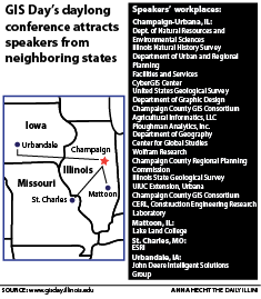
Illinois celebrates modern mapmaking with International GIS Day
November 19, 2014
For Illinois football, it’s time to prove it
August 28, 2014
Close
Close Modal Window
Close