Sanganois State Conservation Area in danger of destruction

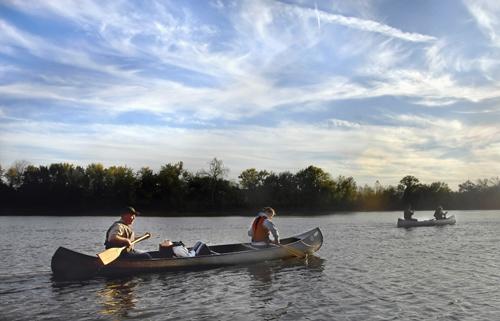
Mark Wertz and his daughters, Alissa and Lauren, paddle toward the setting sun as they re-enter the Illinois River from Sanganois Conservation Area to return to their put-in point in Browning, Ill., on Oct. 19, 2008. David Zalaznik, The Associated Press
Feb 12, 2009
BROWNING, Ill. (AP) – Eric Schenck was rooted in the present once again, his Alumacraft canoe firmly strapped to the roof of his Ford Explorer after 3.5 hours of paddling through one of the last great expanses of wetland wilderness in central Illinois.
Physically, Sanganois State Conservation Area is 10,000 acres of slough, marsh, lake and wetland – terrain much like the geography up and down the Illinois River 100 years ago. Emotionally and intellectually, Schenck has concluded, the swamp represents much more and touches upon something deep in our genetic makeup.
Illinois’ regional biologist with Ducks Unlimited, Schenck was pondering the trip into the Sanganois as he drove home in the dark. He had paddled back in time and was ruminating about the loss of a world he’d just seen and the damaging ecological consequences triggered by its destruction.
But he is a realist and a scientist, acknowledging the evolution of nature, man and society.
At home, he easily summed up his scholarship, experience and passion:
Get The Daily Illini in your inbox!
“Some may wonder whether or not an area like this is really under threat and consequently if protection is even needed. Who is to say? However, the vast changes that have occurred in the past 100 years suggest that nothing stays static and that without conservation, this area, too, could be lost. It takes people … committed to the idea of establishing conservation legacies for their children and grandchildren to make this happen.”
Four people deeply committed to that notion of conservation stewardship slipped canoes into a swift-flowing Illinois River at Browning alongside Schenck’s Alumacraft earlier that Sunday afternoon.
The paddlers battled a wind from the south for 1.5 miles. Someone screamed when an Asian carp jumped from the river, narrowly avoiding a boat.
Then the canoes glided into Pluckeman Slough, and the world was transformed. This entry point into Sanganois State Conservation Area is a portal from present to past. It is the region where the Sangamon River flows into the Illinois River, and it’s so vast and disorienting, boaters are advised to take maps and global positioning satellite devices.
In the 1950s, the U.S. Army Corps of Engineers channelized the Sangamon, but ever since then, the river has been working its way home, back to its old patterns of braided, wiggly waterways. The notion of straightening out the Sangamon failed to appreciate the river’s patience and power.
After half a century, the Corps’ channel is pretty well silted in, and the old jumble of rivulets is reclaimed. Paddle around an approaching bend a few times, and it becomes impossible to verify direction without a compass.
“Everything has a consequence. Sometimes you can get away with channelization, but you never get away with breaking the laws of physics,” Schenck said.
The total trip was five miles, and paddlers emerged back on the Illinois River as a setting sun illuminated thin, wispy cirrus clouds streaking over the western horizon. The kind of clouds that look revelatory.
“It is really amazing to think that 100 years ago, most of the Illinois River Valley was like what we saw during our canoe trip. Most of the changes happened in my grandfather’s lifetime,” Schenck said. “It is exciting to think that we can act to protect this last wilderness-like area during our lifetimes so that our children and our grandchildren can have the opportunity to experience it.”


