


Urbana accepts revised agreement with geographic tool consortium
February 6, 2014
Police officers in Champaign County have a unique tool at their disposal. When they receive a call about a disturbance, they can enter the address into a database that connects officers to an array of information about the destination, such as names of property owners, or directions to the site.
This “Geographic Information System,” said Leanne Brehob-Riley, director of the Champaign County GIS Consortium, can be a very valuable tool in the planning stages of major operations.
“We’ve had officers come in … if they know there’s drugs in an area and they want to plan out the best way to get to the property … they’ll come in and ask for aerial photos,” she said.
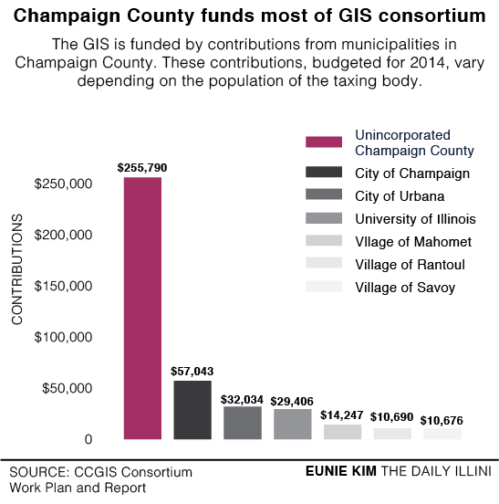
The county’s GIS is provided by the Champaign County GIS Consortium, an entity composed of seven members: unincorporated Champaign County (the area of the county not directly governed by municipalities), the City of Champaign, the City of Urbana, the University of Illinois, the Village of Rantoul, the Village of Mahomet and the Village of Savoy.
Each of these members pays a fee to gain access to the system. The fees are based on the population of each body. Additionally, the consortium receives about $100,000 in additional revenue selling the map data to private entities. But on Monday, the Urbana City Council passed a resolution to change the language in their agreement with the consortium. The updated language clarifies the role of technical advisors and also updates the process of data disclosure to non-member agencies.
Get The Daily Illini in your inbox!
Urbana City Council member Diane Marlin, Ward 7, said she had seen similar tools before that stored more information and tied it to property addresses. She said the current GIS was, in comparison, slightly outdated.
Nevertheless, the GIS database is the groundwork for engineering projects, sewer systems and tax information, said Bill Gray, Urbana director of Public Works.
“It’s a very useful tool for (city staff) in our daily work,” he said.
Additionally, residents can access the spatial data maintained by the consortium. Users can look at aerial maps of the county ranging from 1973 to 2011, as well as terrain data and other tools that help chart out school districts, voting precincts and more.
Gray said the current GIS could use some improvements, and city staff members are currently working on a proposal to bring before council later this year.
“We really, really need to update our work order and asset management system … we could (have all the capabilities of other systems), but we have to have that software tool,” he said, adding that the upgrade to the system would be costly.
Eli can be reached at [email protected].